- Cross-border database on the cultural heritage of the Slovenian-Hungarian cross-border region – from 120 selected settlements of the Prekmurje Region in Slovenia and Vas County in Hungary
Archive Material

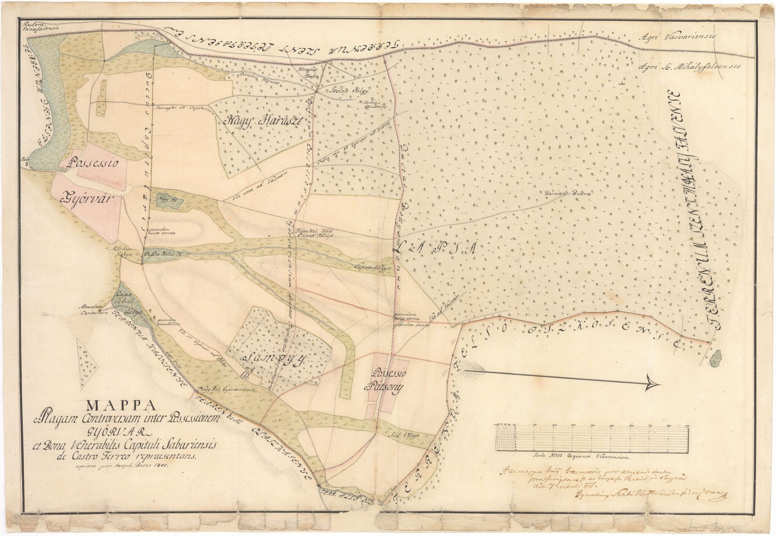
Ragam controversam inter Possessionem Győrvár et Bona Venerabilis Capituli Sabariensis de Castro Ferreo repraesentans
document
Joseph Baczo
1805
paper
The territorial base unit of medieval agriculture was the rotation (‘nyomás’). The plots were scattered around the settlement in several different patches. Consolidation is the process in which farmers' scattered plots of small pieces are merged and each owner receives his land as one contiguous area. The consolidation began after the enactment of the laws of 1836, in parallel with the abolition of lordships. However, in most places, the consolidation took place in the second half of the 19th century and around the turn of the century.
Information on digitization
- Name of site
- Győrvár
- Other settlement names
- Bodóhegy
- Length
- 1 db.
- Specialist description
- A tagosítás településre gyakorolt hatása elsősorban a tanyafejlődés terén figyelhető meg. Olyan vidékeken is megindult a tanyafejlődés, ahol erre a falvak úrbéres jogállása és viszonylag kis határa miatt előzőleg nem volt példa. Egyes helységekben a külterület tagosítását egybekapcsolták a halmazos belterület utcássá rendezésével. Egy-egy helység esetében a tagosítás elmaradása, ill. késése a régi határhasználati rendszerek fennmaradását és a régi települési sajátosságok továbbélését eredményezte. Az úrbéri/tagosítási térképek valójában a földbirtokkönyvek mellékletei, amelyek listaszerűen sorolják fel a birtokokat.
- Written sources
- Simonffy Emil: A parasztföld és a tagosítás (A parasztság Magyarországon a kapitalizmus korában, szerk. Szabó István, 1848–1914, I. Bp., 1965)
- File name
- MNL_VaML_0047_B_0021
- Resolution
- 300 dpi
- Restrictions on use
- Korlátozás nélkül
- Date of documentation
- 2020-02-13
- Person documenting
- Kóta Péter
Photo gallery
3D visualisation of the digitised material